As a result of a very long series of events, we didn’t end up making it to the mountains to hike for Carly’s birthday last weekend, forcing us to reschedule to this weekend. Going for a hike for our birthdays has become somewhat of a tradition the past few years and it was better late than never! I already had the hike picked out, so it made it easy to decide where we were heading – the Sugarloaf Mountain trailhead near Boulder. Only we weren’t there for Sugarloaf Mountain. Although I’m sure we’ll return someday to tackle that magical sounding mountain, our sights were set a little further to Bald Mountain. This is not to be confused with my failed attempt at Old Baldy last year (I still plan on going back and conquering that one!) I chose this hike because this part of the state, near Nederland and Boulder, is one of my favorite parts of the state to hike because I usually see some sort of wildlife and every hike has offered a challenge, with spectacular views as the payoff. The perfect combination if you ask me.
We arrived at the trailhead a little after 10am on Saturday, and I’d be lying if I said I wasn’t at least a little concerned that there would be no parking that close to Boulder on such a nice day. There were maybe 10-15 cars there, and there were already people making their own spots amongst the trees. We were lucky, though, and someone left a more “designated” parking spot right when we were wondering what to do. It’s nice when things work out like that.

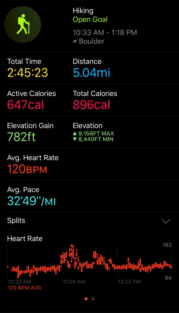
As I mentioned before, there are two trails from this same trailhead, Sugarloaf Mountain, which was much shorter, and Bald Mountain that was about 5 miles. Since this was actually the first time we’ve been up to the mountains hiking this year, we decided we better make the most of it and go for the longer one, and just hoped that the rain we could see all around us would hold off.
The first part of the trail wasn’t exactly promising, and we had to stop and ask people if we were even going the right direction. The cars driving down the road didn’t give us much hope either, but we pressed onward, and despite the less than stellar “trail” situation, the views were still spectacular


We eventually realized that we missed the first turn-off for the trail, which would take you around the loop counterclockwise and the way the arrows pointed on AllTrails, but we did find the second turn off that took us clockwise. Looking back, I wish we would’ve seen the first turnoff, because this direction seemed like it was much more difficult.


The route was steep, with many rocks and loose dirt to make the risk of slipping that much higher. Looking at the pictures, it doesn’t really give it justice. We also realized (again, after the fact) that we went off the trail for a little bit, taking a shortcut which proved to be the steepest part. It would’ve been easier to stay on the correct trail if we were going around the loop in the correct direction, but again, lessons learned for next time!

We reached what we thought had to be the top of the mountain because of how steep the climb had just been, and how spectacular the views were!


Like everything else up to this point, we were also wrong about this being the top of the mountain, and continued upward. The wildflowers continued to amaze throughout our entire journey, adding that extra sparkle of beauty to an already magnificent hike. As always, at a certain point, I have to let the pictures do the talking for me, otherwise I could go on and on!


We did finally make it to what was actually the top of the mountain, and let me tell you, the payoff at the top was worth the hard climb! We didn’t see another hiker the entire time, and could’ve spent all day at the top in the solitude, listening to the chirps of the few birds that were around us up there.


As any seasoned hiker can tell you, the worst part of any hike is coming back down. That was certainly true of this one, where the descent was almost as steep as our climb. It made every single step treacherous, and we took the tiniest steps we could as we made our way down, just hoping that our knees didn’t give out on us. As you can imagine, I wasn’t taking pictures during the worst of it, but hopefully these pictures do it a little bit of justice.


Despite there being a few spots where the steepness of the terrain made us slightly uncomfortable, it was still one of our favorite hikes we’ve been. Between the wildflowers and the spectacular views, it was everything we could hope for, and I could definitely see us coming back to do this hike again or to tackle the Sugarloaf Mountain peak. There may have been more people on that trail, but we didn’t see a single other hiker on our trail the entire time, except for right at the beginning when we asked for directions. That’s hard to achieve this close to Boulder. We found the only problem with doing a really long hike during a pandemic, though, is not being able to stop at a restaurant at the bottom for a beer! Time to start planning the next adventure!!